Trail Horseback riding Pont de Montvert - Sud Mont Lozère - Equestre 6 - Photo
© OpenStreetMap contributors
Length
Length
68 km
Max alt
Max alt
1637 m
Uphill gradient
Uphill gradient
1857 m
Km-Effort
Km-Effort  
92 km
Min alt
Min alt
584 m
Downhill gradient
Downhill gradient
1848 m
Boucle
Boucle
Yes
Creation date :
2020-04-28 08:52:24.657
Updated on :
2020-07-09 14:59:06.29

(0 Reviews)

Horseback riding
Horseback riding
--
Difficulty : Unknown

Scan this QR Code to open this trail in the SityTrail application

FREE GPS app for hiking

Logo SityTrail SityTrail

IGN / Geographical institutes

Download SityTrail from the App Store Download SityTrail from Google Play

Logo SityTrail SityTrail World

The world is yours!

Download SityTrail from the App Store Download SityTrail from Google Play Download SityTrail on Huawei AppGallery

About

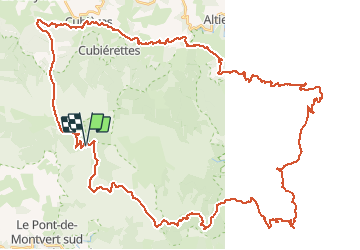
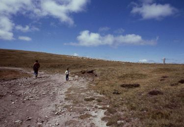
Trail Horseback riding of 68 km to be discovered at Occitania, Lozère, Pont de Montvert - Sud Mont Lozère. This trail is proposed by Lozère Cheval.

Description

Herminie Gravier groupe pole pleine nature Mt Lozère

Elevation profile

Points of interest

Point of interest Mont Lozère et Goulet - Hôtel le Refuge - Photo
Lozère Cheval
MONT LOZÈRE ET GOULET 
Point of interest Villefort - Mas Affenadou - Photo
Lozère Cheval
VILLEFORT 
Point of interest Vialas - Mas de la Barque - Photo
Lozère Cheval
Point of interest Mont Lozère et Goulet - Gite de l'Escoutal - Photo
Lozère Cheval
MONT LOZÈRE ET GOULET 

Positioning

Country:
France
Region :
Occitania
Department/Province :
Lozère
Municipality :
Pont de Montvert - Sud Mont Lozère
Location:
Le Pont-de-Montvert
Start:(UTM)
561400 ; 4918003 (31T) N.

Trails nearby

Trail Mountain bike Cubières - TOUR MONT LOZERE - Photo
Mountain bike
asclier0

Mountain bike

Very difficult
(1)
Cubières, Occitania, Lozère, France
38 km | 47 km-effort
3h 14min
Yes
Trail Walking Pont de Montvert - Sud Mont Lozère - Finiels/ sommet / station du Bleymard en boucle - Photo
Walking
GUIDE
nadinebondoux

Walking

Difficult
Pont de Montvert - Sud Mont Lozère, Occitania, Lozère, France
20 km | 30 km-effort
5h 38min
Yes
Trail Walking Pont de Montvert - Sud Mont Lozère - Cévennes Mas Camargues Pont du Tarn - Photo
Walking
HO49

Walking

Easy
(1)
Pont de Montvert - Sud Mont Lozère, Occitania, Lozère, France
7.4 km | 8.6 km-effort
2h 7min
Yes
Trail Walking Mont Lozère et Goulet - sources du tarn - Photo
Walking
olivier78000

Walking

Medium
(1)
Mont Lozère et Goulet, Occitania, Lozère, France
13.3 km | 17.3 km-effort
3h 50min
No
Trail Electric bike Cubières - ETANG DE BARANDON PAR LA STATION DE SKI - Photo
Electric bike
asclier0

Electric bike

Medium
Cubières, Occitania, Lozère, France
31 km | 36 km-effort
2h 11min
Yes
Trail On foot Pont de Montvert - Sud Mont Lozère - Sentier de Mas Camargues - Photo
On foot
GUIDE+

On foot

Easy
Pont de Montvert - Sud Mont Lozère, Occitania, Lozère, France
3.1 km | 3.9 km-effort
52min
Yes
Trail On foot Pont de Montvert - Sud Mont Lozère - chemin de Malevrère - Photo
On foot
GUIDE+

On foot

Easy
Pont de Montvert - Sud Mont Lozère, Occitania, Lozère, France
3.1 km | 4.4 km-effort
1h 0min
No
Trail Walking Mont Lozère et Goulet - Le Finiels - Photo
Walking
richardsimopons

Walking

Difficult
Mont Lozère et Goulet, Occitania, Lozère, France
9 km | 12.3 km-effort
2h 33min
Yes
Trail Walking Mont Lozère et Goulet - 210617 - Mont Lozère  - Photo
Walking
randodan

Walking

Easy
Mont Lozère et Goulet, Occitania, Lozère, France
7.1 km | 9.3 km-effort
1h 22min
Yes


Close
My subscriptions